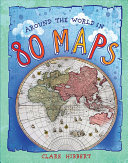
Gr 4–7—Colorful? Yes. Vintage look? Yes. Old world charm? Yes. But it's unclear for whom this book of centuries-old maps, culled from the collection of the British Library, is intended. Granted, given GPS, GoogleEarth, and other technologies, today's kids are not as familiar with paper maps, so there may be a curiosity factor for some middle grade readers. Some of the maps are of obscure places (such as the capital of Tibet, or Kyushu, a small Japanese island). The maps are gorgeous pieces of art, accompanied by tidbits of information as well as a "find me" search game on each page. There's much to learn here—some readers may not know that North and South Korea used to be one country or that Calcutta was once spelled Kolkata. But it's hard to imagine many readers picking up this book.
VERDICT For geography and maybe ancient history buffs only.
Be the first reader to comment.
Comment Policy:
Comment should not be empty !!!